


The Misliya cliff is a part of the western cliff of Mount Carmel, formed in the Turonian limestone of the Bi'na Formation. The bedrock is massive, with few fractures, thus it is readily karstified.
The studied part of the cliff is ~60 m long and 17-20 m high (sections EE', FF' respectively), towering above a talus with breccia and collapsed blocks extending westward, where the archaeological site is found. The cliff includes a rock shelter ~3 m wide and 15 m long, under a rock overhang, which may have been part of a large cave chamber. Several small caves (or niches) extend eastward from the rock shelter and from the continuation of the cliff northward and southward. The caves extend up to 10 m eastward from the cliff face, but one of the caves is currently filled with debris, and may extend further eastward.
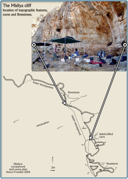
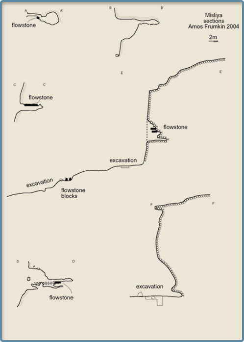
The following features are observed in the caves: smooth walls, tube-like passages with elliptical cross section, ceiling cupolas, and a combination of elongated passages with larger chambers. These features indicate that the caves were formed under the water table, when sea level was close to the top of the escarpment, or the Turonian bedrock had not yet risen to its present elevation. Following the uplift of Mount Carmel the water table sank with respect to the Mediterranean and the caves were dewatered. This begins the vadose stage of the cave's history.
An ancient, inactive flowstone appears in the southern and northern caves (sections AA', CC', DD', EE'). It forms a 0.2-0.5 m thick macrocrystalline calcite layer in the southern cave, and two such layers in the northern cave (section EE'). The flowstone seems to be more resistant to erosion than the bedrock. Some later expansion of the cave occurred above and below the flowstone, while the flowstone itself was undermined and eroded to a lesser degree. It appears that the flowstone was deposited slightly above its coeval water table, followed by a rising water table which reactivated karstic dissolution. Detached blocks of flowstone appear some 20 m west of the cliff within collapsed debris and archaeological breccia (section EE'). Th/U dating of these blocks show that they are older than 650,000 years. Their appearance and old age indicate that most probably they originated from a former westward extension of the flowstone observed in-situ in the northern and southern caves. This extension must have formed a part of the cave system, later destroyed by collapse. Its remains are scattered over and within the archaeological layers, together with collapsed bedrock blocks. The extent of the archaeological breccia roughly delineates the extent of the destroyed cave that seems to have been elongated towards the ENE. The wide extent of the Acheulo-Yabrudian remains in the breccia (up to square Q30) seems to indicate that at the time of the Acheulo-Yabrudian occupation the cave had extended ~30 m from the present cliff-face. A gradual retreat of the cliff face, associated with cave collapse, decreased the cave length to ~10 m west of the present cliff-face today.